Our busy year 2017
Research activities of CRC 1266 project B1 „Pioneers of the North“ during 2017
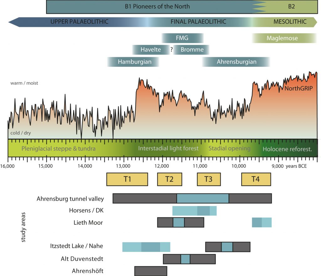
The Late Pleistocene recolonization process of Northern Europe and the socio-environmental transformations during this process are our main research objectives. Therefore, we began our research in the south-western Baltic region where we had identified five main archaeological areas that we wanted to study in different work packages (WP):
- Ahrensburg Tunnel Valley (WP1),
- Lieth Moor area (WP2),
- Itzstedt Lake area (WP4),
- Alt Duvenstedt (WP5), and
- Ahrenshöft (WP6).
To these we hoped to add further areas with the help of predictive modelling that is fed by a database of Late Pleistocene and Early Holocene sites in Schleswig-Holstein (henceforth: Palaeodatabase, WP3). Due to unexpected finds during a preventive excavation in late 2016, we could identify another interesting area near Horsens area / DK that we also began to further investigate (WP8). This newly added area is located within the Weichselian moraines and, hence, completed the representation of our research areas across the main geological formations in the south-western Baltic region. Finally, we wish to synthesise our results (WP7) to help us better understand the four major transformation phases (T1-4) that were already known from the archaeological material from the study area.
In 2017 we began working on several of these WPs with different intensity:
WP1 (Ahrensburg Tunnel Valley): In accordance with our proposal, we meanwhile prepared the digital analysis of this region by collecting further information for a 3D reconstruction and incorporating them in a Geographical Information System (GIS). Besides geological data, detailed archaeological information as published by Rust (1958) and Tromnau (1974) from the Teltwisch and Borneck sites have been added into the GIS. Some of the archaeological information from this area still needs revision and has to be updated to modern archaeological techno-typological analytical practices.
A 3D area model is created with the help of this information. It will help to show the geomorphological changes of the landscape on a sub-regional level, not just in this study area but also in the Lieth Moor area, the Itzstedt Lake area, and in Ahrenshöft. These changes were still ongoing during the Late Pleistocene and people in the Final Palaeolithic had to adapt to them. We can only consider transformations of the socio-environmental interaction when knowing more about these changes and their internal chronology. Yet, the interpolations of the 3D information cannot be performed as straight forwardly as previously expected due to the various geological problems. The spatial significance of this data is on sub-regional levels with very different hypotheses depending on their chronological relevance. For example, the stratigraphic data from the Ahrensburg Tunnel Valley must be further differentiated to fit our purpose of creating syntheses for different periods represented in this area. Based on this data collection, a first discussion about human use of this landscape and the transformations between the periods can then be accomplished.
WP2 (Lieth Moor area): For the Lieth Moor area, we have also created a GIS based on the thus far known data collections from archaeology as well as from geology. In September 2017, we could join the Archaeological State Agency Schleswig-Holstein (ALSH) in a pre-construction survey in this area where some test trenches were cut with a mechanical digger. During this campaign, we extracted several sediment sequences with a modified Livingston piston corer (“Usinger Bohrer”) in order to receive a detailed palaeoenvironmental record. These efforts impressively showed that the geological formation in this area is highly complex and organic material poorly preserved. This was equally visible from the collected, partially contradicting geological data. The complex results made it clear that, prior to further field surveys, we need to discuss the available information with geological experts (Kay Krienke, Geological Survey SH/ LLUR, Alf Grube, Geological Survey HH). Based on this discussion, we may be able to also reflect the development of this find area and the use of it by hunter-gatherer groups of the Late Pleistocene and Early Holocene. In fact, based on a survey of all archaeological reports from Klein Nordende, Elmshorn, Tornesch, Heidgraben, and Seeth-Ekholt recorded in the ALSH records, the richness of this area becomes apparent with some 75 findspots from the Stone Ages of which at least 40 assemblages could be attributed to the Palaeolithic or Mesolithic period. We also began reviewing some of the Final Palaeolithic assemblages to understand in more detail possible transformations in the use of the lithic materials as well as the use of different locations over time.
WP3 (Palaeodatabase): We successfully worked on the connection of the Palaeodatabase to the database of the ALSH, enabling us to locate the known sites precisely and to then look for new promising sites in collaboration with sub-project A2. We also occasionally went to the field to test a few sites in Schleswig-Holstein as well as Mecklenburg-Vorpommern for their potential in answering questions about human environmental interactions. Also in this WP we can subsume the work on legacy data from the late Hartmut Usinger that Sascha Krüger used to establish a first overview of the palynological record available to inform us about the Late Pleistocene in Schleswig-Holstein. A first result was the identification of a promising coring spot in the Itzstedt Lake area (see below).
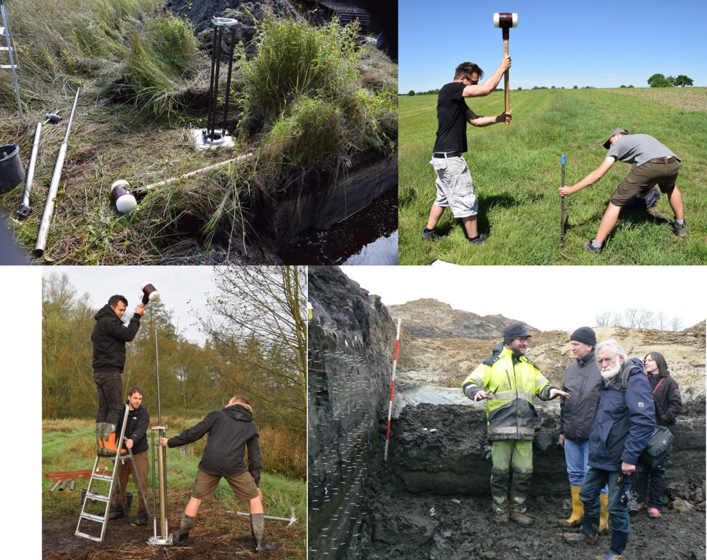
WP4 (Itzstedt Lake area): Near Lake Itzstedt, our current work focused on retrieving sediment cores for palaeoenvironmental analyses from a Lateglacial lake that was located in the upper valley of the Rönne. In October 2017, the Natural Protection Authority finally allowed us to drill two 16m long cores from a point where Hartmut Usinger located Lateglacial laminated sediments. This field campaign was performed in collaboration with Jan Weber (E1) and the analyses of the sediment cores will be performed in a close collaboration with the geochemistry from E1 and the palynological and sedimentological expertise of sub-project F2 (Stefan Dreibrodt). Hamburgian and Ahrensburgian sites are known from this area and in a situation comparable to the Stellmoor site in the Ahrensburg Tunnel Valley. Previous excavations uncovered faunal material, in particular reindeer, from the littoral areas of the lake from which these sediment cores were taken. We therefore hope to establish a good correlation of the environmental and the archaeological data. In particular, Sascha Krüger aims to understand the human use of the landscape by using charcoal analysis on this sequence allowing him to discuss questions about the human-environmental interactions.
WP7 (Synthesis): Together with Vesa Arponen (A1), Sonja B. Grimm already approached questions relating to a meta-level of our project: How do we have to imagine the colonisation process? What do we already know? How did we come to know this? And what do we need to close the gaps of what we do not know yet? Preliminary results were presented at the EAA meeting in Maastricht and a publication is in preparation.
Studying our material, we are constantly alternating between the analyses of the data from a single collection/site and the comparison with the regional record to the record across Schleswig-Holstein, the south-western Baltic region, or Northern Europe. By this comparison, we are crossing different scales at which change can work and we are reflecting on what large scale changes could mean for a single group as well as how the changes can spread from a single person across a whole society. For this we also collaborate closely with B2 to establish a joint lithic analytical approach that will enable us in the future to compare our material more directly. With this type of direct comparison it will be possible in the future to show the small steps that lead to the major transformation from Palaeolithic to Mesolithic societies in more detail.
WP8 (Horsens area): Sascha Krüger participated in the excavation in Tyrsted and extracted some sediment cores for palaeoenvironmental studies with Morten Fischer Mortensen from the National Museum of Denmark with whom we will collaborate in this region. Furthermore, the Horsens Museum will be a collaboration partner in this area. Together with the geophysics sub-project (G2), we analysed the kettlehole area in the vicinity of the Tyrsted excavation (http://www.zbsa.eu/juni).
In 2017, the members of our team were:
Prof. Dr. Berit V. Eriksen (PI),
Dr. Sonja B. Grimm (Post-Doc),
Sascha Krüger M.A. (PhD),
Dr. Mara-Julia Weber (ZBSA),
Katja Winkler M.A. (research assistant),
Benjamin Serbe M.A. (student then research assistant),
Tobias Burau B.Sc. (student assistant).