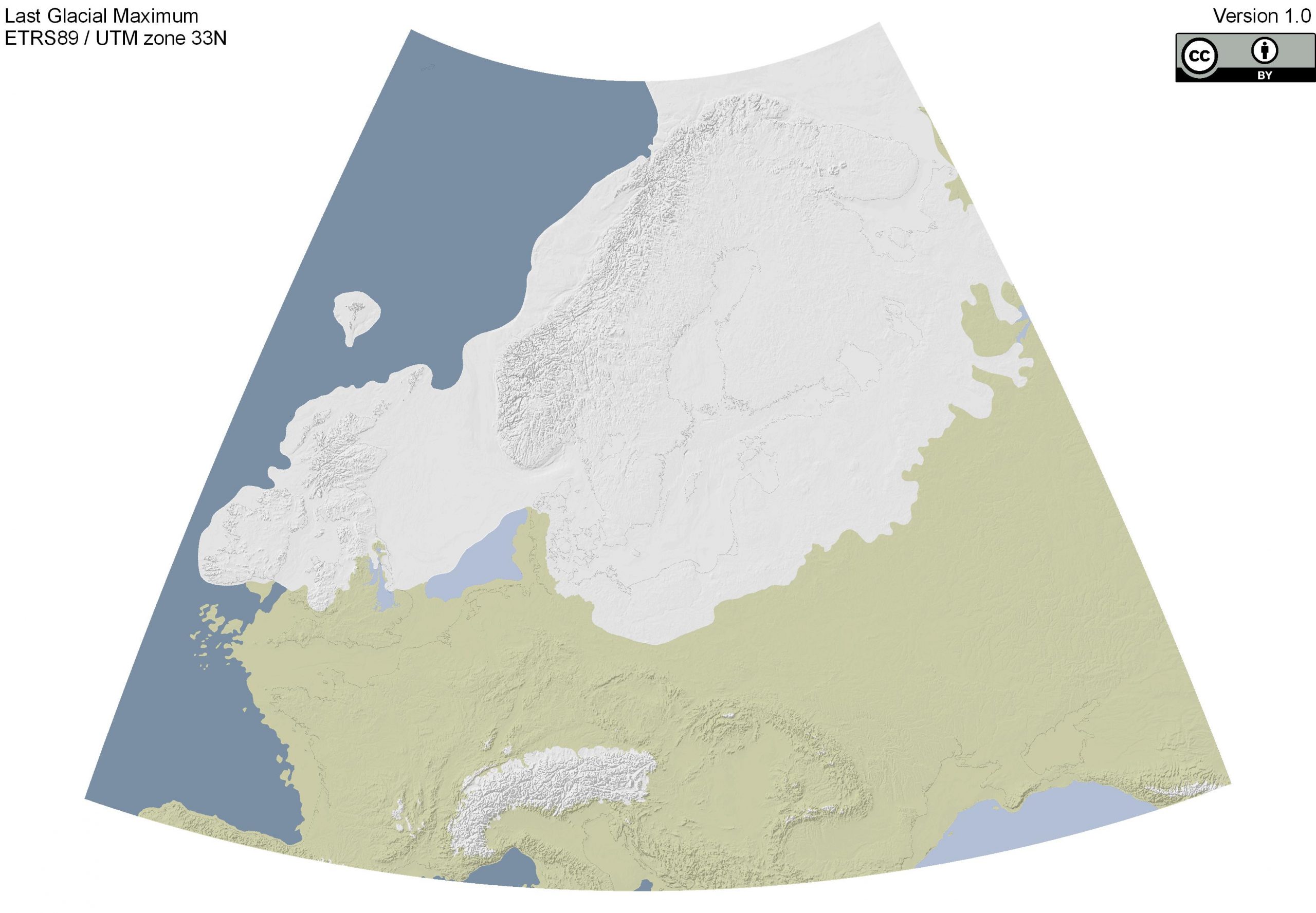
Last Glacial Maximum
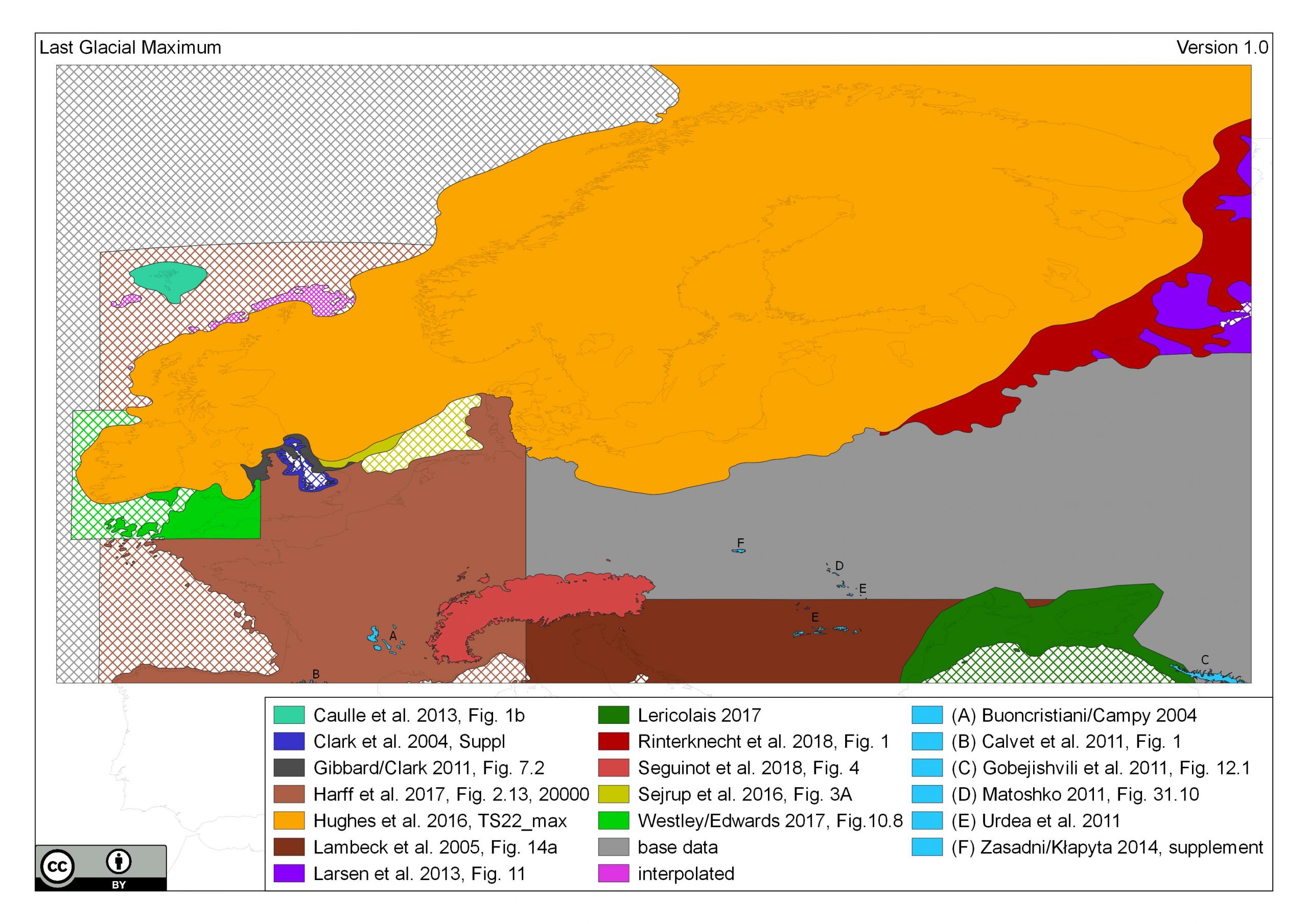
Please cite this map as „compiled by ZBSA after Bouncristiani /Campy 2004; Calvet et al. 2011; Caulle et al. 2013; Clark et al. 2004; Gibbard/Clark 2011; Gobejishvili et al. 2011; Harff et al. 2017; Hughes et al. 2016; Lambeck/Purcell 2005; Larsen et al. 2013; Lericolais 2017; Matoshko 2011; Rinterknecht et al. 2018; Seguinot et al. 2018; Sejrup et al. 2016; Urdea et al. 2011; Westley/Edwards 2017; Zasadni/Kłapyta 2014“
For full references see below.
The map is approximately representing the timeslice:
| chronological frame | timeslice |
| Greenlandic isotope chronology | GS-3 |
| years calibrated BC | 25500–17500 |
| year calibrated BP | 26500–19500 |
| 14C years BP | 22000–16190 |
This work is licensed under the Creative Commons Attribution 4.0 International License. To view a copy of this license, visit https://creativecommons.org/licenses/by/4.0/

The archive contains different files. A processed high resolution Geotiff in UTM 33N (1200 dpi), a processed JPG in UTM 33N (300 dpi), the raw Geotiff in WGS84, the used Source SHP File with their secondary files, the “sources map” PDF and the release notes PDF.
The processed UTM 33N Geotiff and JPG are designed for simple and direct usage, while the raw WGS84 Geotiff is for work in different map projections. The original SHP-Files are for work with alternative colour ramps or detailed insight on the used sources and specific reasons for interpolation.
This is map version 1.0. The map extent is defined from 12°W to 44°E and 43°N to 72°N. All Data were digitalised from different sources (See sources map) which are listed further down on this site.
The modern coastline is derived from Natural Earth (https://www.naturalearthdata.com), large lakes were added from the “WISE Large rivers and large lakes” dataset provided by the European Environment Agency (https://www.eea.europa.eu/data-and-maps/data/wise-large-rivers-and-large-lakes). Finally, the shaded elevation is calculated on the “GEBCO One Minute Grid” from the “GEBCO Gridded bathymetric Data” (https://www.gebco.net/).
The maps were produced with QGIS 3.
- Reconstructed Landmasses from Harff et al. 2017 north of the BIIS/FIS was removed.
- Sea level for the Black Sea was set to -120 m a.s.l. based on sea level curve from Lericolais 2017
- Minor adjustments were made to smoothen the coastline
| 09-08-2019 | release of version 1.0.1 |
| 13-06-2019 | 1st release of the map |
- Corrected spelling (“ice sheet” instead of “ice shield”) in release notes and shape files
Bouncristiani, J.-F., Campy, M. 2004: Palaeogeography of the last two glacial episodes in the Massif Central, France. In: Ehlers, J., Gibbard, P. L. (Eds.), Quaternary Glaciations – Extend and Chronology: Elsevier, 111-112
Calvet, M., Delmas, M., Gunnell, Y., Braucher, R., Bourlès, D. 2011: Recent Advances in Research on Quaternary Glaciations in the Pyrenees. In: Ehlers, J., Gibbard, P. L. (Eds.), Quaternary Glaciations – Extend and Chronology, A Closer Look: Elsevier, 127-139
Caulle, C., Penaud, A., Eynaud, F., Zaragosi, S., Roche, D. M., Michel, E., Boulay, S., Richter, T. 2013: Sea-surface hydrographical conditions off South Faeroes and within the North-Eastern North Atlantic through MIS 2: the response of dinocysts. Journal of Quaternary Science 28(3), 217-228
Clark, C. D., Evans, D. J. A., Khatwa, A., Bradwell, T., Jordan, C. J., Marsh, S. H., Mitchell, W. A., Bateman, M. D. 2004: Map and GIS database of glacial landforms and features related to the last British Ice Sheet. Boreas, 33(4), 359-375
Gibbard, P. L., Clark, C. D. 2011: Pleistocene Glaciation Limits in Great Britain. In: Ehlers, J., Gibbard, P. L. (Eds.), Quaternary Glaciations – Extend and Chronology, A Closer Look: Elsevier, 75-93
Gobejishvili, R., Lomidze, N., Tielidze, L. 2011: Late Pleistocene (Würmian) Glaciations of the Caucasus. In: Ehlers, J., Gibbard, P. L. (Eds.), Quaternary Glaciations – Extend and Chronology, A Closer Look: Elsevier, 141-147
Harff, J., Flemming, N. C., Groh, A., Hünicke, B., Lericolais, G., Meschede, M., Rosentau, A., Sakellariou, D., Uścinowicz, S., Zhang, W. and Zorita, E. 2017: Sea Level and Climate. In: Flemming, N. C., Harff, J., Moura, D., Burgess, A. and Bailey, G. N. (Eds.), Submerged Landscapes of the European Continental Shelf: Wiley & Sons, 11-49
Hughes, A. L. C., Gyllencreutz, R., Lohne, Ø. S., Mangerud, J., Svendsen, J. I. 2016: The last Eurasian ice sheets – a chronological database and time-slice reconstruction, DATED-1. Boreas, 45, 1-45
Lambeck, K., Purcell, A. 2005: Sea-level change in the Mediterranean Sea since the LGM: model predictions for tectonically stable areas, Quaternary Science Reviews, 24, 1969-1988
Larsen, E., Fredin, O., Jensen, M., Kuznetsov, D., Lyså, Subetto, D. 2013: Subglacial sediment, proglacial lake-level and topographic controls on ice extent and lobe geometries during the Last Glacial Maximum in NW Russia. Quaternary Science Reviews 92, 369-384
Lericolais, G. 2017: Late Pleistocene Environmental Factors defining the Black Sea, and Submerged Landscapes on the Western Continental Shelf. In: Flemming, N. C., Harff, J., Moura, D., Burgess, A. and Bailey, G. N. (Eds.), Submerged Landscapes of the European Continental Shelf: Wiley & Sons, 479-495
Matoshko, A. V. 2011: Limits of the Pleistocene Glaciations in the Ukraine: A Closer Look. In: Ehlers, J., Gibbard, P. L. (Eds.), Quaternary Glaciations – Extend and Chronology, A Closer Look: Elsevier, 405-418
Rinterknecht, V., Hang, T., Gorlach, A., Kohv, M., Kalla, K., Kalm, V., Subetto, D., Bourlès, D., Léanni, L., Guillou, V., ASTER Team 2018: The Last Glacial Maximum extent of the Scandinavian Ice Sheet in the Valday Heights, western Russia: Evidence from cosmogenic surface exposure dating using 10Be, Quaternary Science Reviews, 200, 106-113
Seguinot, J., Ivy-Ochs, S., Jouvet, G., Huss, M., Funk, M., Preusser, F., 2018: Modelling last glacial cycle ice dynamics in the Alps. The Cryosphere, 12, 3265-3285
Sejrup, H. P., Clark, C. D., Hjelstuen B. O. 2016: Rapid ice sheet retreat triggered by ice stream debuttressing: Evidence from the North Sea. Geology, 44 (5), 355-358
Ureda, P., Onaca, A., Ardelean, F., Ardelean, M. 2011: New Evidence on the Quaternary Glaciation in the Romanian Carpathians. In: Ehlers, J., Gibbard, P. L. (Eds.), Quaternary Glaciations – Extend and Chronology, A Closer Look: Elsevier, 305-322
Westley, K., Edwards, R. 2017: Irish Sea and Atlantic Margin. In: Flemming, N. C., Harff, J., Moura, D., Burgess, A. and Bailey, G. N. (Eds.), Submerged Landscapes of the European Continental Shelf: Wiley & Sons, 241-279
Zasadni, J., Kłapyta, P. 2014: The Tatra Mountains during the Last Glacial Maximum, Journal of Maps, 10 (3), 440-456